
By itself or combined with other technologies (for example: sensors, geolocation, robotics), AI can perform tasks that would otherwise require human intelligence or intervention. Digital attendees, GPS guide, autonomous vehicles, detection of fires and pollution episodes and generative artificial intelligence tools are just some of the examples of artificial intelligence that are regularly used.
As a field of computer science, Artificial intelligence encompasses several disciplines that involve the development of algorithms of AI, modeled based on the decision -making processes of the human brain, which can “learn” from the available data and make classifications or predictions more and more precise over time.
In this case, this type of solutions will be used so that The new technological platform helps Galicians fight fires, either when preventing them, as if to locate them as soon as possible and turn them off.

Prevention of incendures en galicia
The Xunta de Galicia promotes the use of Artificial intelligence for – among other possible uses – the detection of forest fires, The cartography of forest tracks or the management of alerts before fires of special gravity and latest generation.
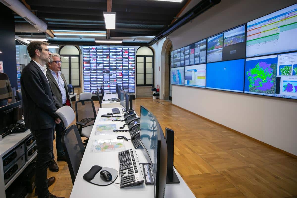
This was announced today by the director of the Agency for Technological Modernization of Galicia, Julián Cervino, during the visit he made to Central Coordination Center of Defense against Forest Fire. The agency director was received at the Control Center by the General Director of Defense of the Monte, Manuel Rodríguez, and his team.
Technologies that use artificial intelligence are being introduced to Give new mood in support information systems in real -time management of fires in Galiciawhich are already a reference both nationally and European.
Artificial Intelligence against fires
The Xunta opted for the development of specific systems and adapted to the needs of the territory from an avant -garde position. The heart of the system and xeocode 3.0 has Up to 16 satellite applications that charge all areas of fire prevention and extinction.
Is applications allow the location and monitoring of an extensive operation composed of about 20 cargo aircraft and own helicopters; 400 terrestrial media, such as motobombs, tanks or heavy machinery; and more than 7,000 people in high -risk periods.
Technicians who participate in an operation have Real -time information about fire management in which they participate through tablets and mobile phones. These utilities also allow you to have cartographic information, search toponyms, locate the assigned resources or know the best access routes.
He Coordination Center has access to the Forest Space Surveillance Network of Galiciawhich is in the process of expanding with 12 new centers. This network allows the most risky areas to be monitored and monitor more than 85% of the Galician territory.
You also work evaluating simulators who can help anticipate the evolution of forest fires At any point in the community based on the combustible properties of forest mass, the characteristics of the land and the weather conditions.