
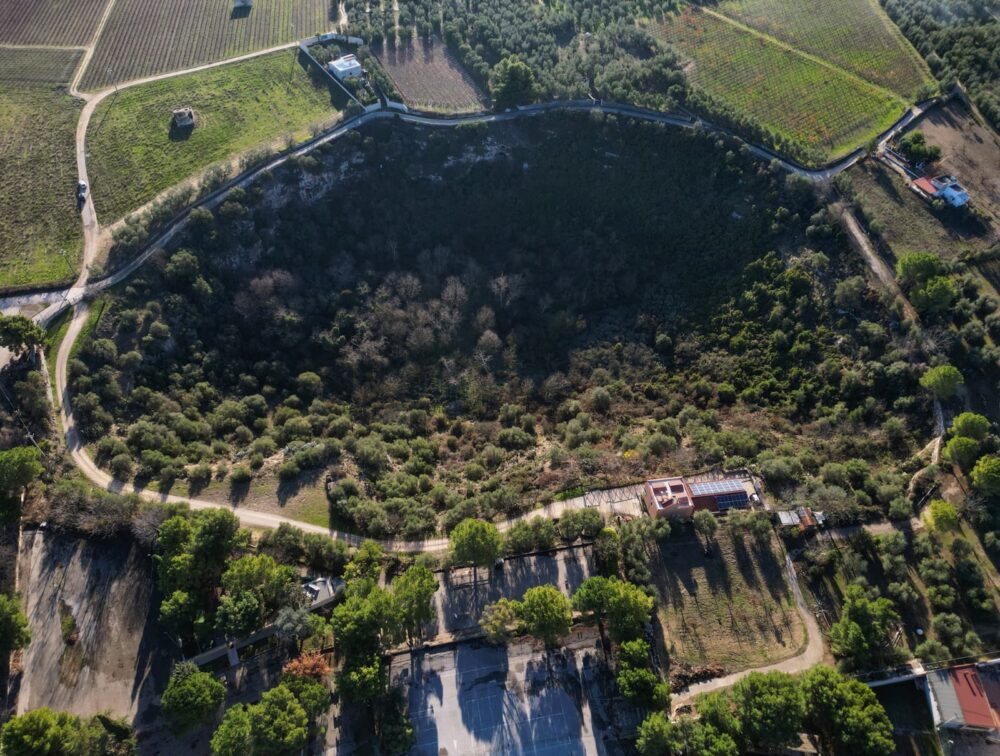
GURGO DI ANDRIA IS ONE OF THE FIVE LARGEST AND SPECTACULAR DOLINES IN PUGLIA, JUST MORE THAN ONE KILOMETER SOUTH-WEST OF THE TOWN OF BAT. THE GEOSITE, IN THE SANTA MARIA CONTRADA, HAS BEEN INDICATED TO BECOME A HYDRAULIC SYSTEM WORK
«The Gurgo of Andria – explains Giovanna Amedei, president ofOrder of Geologists of Puglia – it is one of the five largest and most spectacular sinkholes in Puglia which is located just over a kilometer south-west of the city of Andria, in the Santa Maria district and they want to transform it into a lamination tank!».
A retention pond is an infrastructure used to manage rainwater or river water, designed to reduce the risk of flooding.
The issue was addressed by the SIGEA, Italian Society of Environmental GeologyWhy «in addition to the landscape and cultural value of Gurgo – adds Amedei – two important technical aspects must be considered: groundwater contamination and hydroseismic effects.”
The idea of building the lamination tank at Gurgo is part of the planning of interventions against the hydrogeological instability and make the rural area safe. This structure acts as a temporary storage basin, collecting excess water during heavy rainfall events or river floods, then gradually releasing it into the natural or artificial flow system.
But what value does the geological heritage in Puglia have?
«Let’s make a premise – continues the SIGEA president -, the safety of the town is absolutely not in question and neither are the hydrogeological risk mitigation interventions, but the problem is the choice of Gurgo which, perhaps, the studies supporting the project did not adequately consider”.
Gurgo, one of the five most impressive and fascinating sinkholes in Puglia, extends just over a kilometer south-west of Andria, in the Santa Maria di Trimoggia district. This extraordinary place is not only a symbol of landscape and cultural value, also recognized by the Italian Society of Environmental Geology, but also represents a geosite. This status derives from its inclusion in the regional census pursuant to LR 33/2009 and from its recognition as “other contexts” within the PPTR of the Puglia Region. Consequently, Gurgo is subject to Article 56 of the relevant Technical Implementation Regulations (NTA), which prescribes specific safeguard and use measures for the “Hydro-geo-morphological structure”.
Environmental protection is at risk
In addition to these regulatory constraints, Gurgo raises two fundamental technical issues for environmental protection: the contamination of the aquifer and hydroseismic effects. Studies on the Alta Murgia area have highlighted a worrying phenomenon. During intense rainfall, pollutants are transferred through fractures in the ground and endorheic karst forms. These natural structures act as direct channels between surface activities and the underground aquifer.
Using the Gurgo as a storage area would aggravate this problem, favoring an even more rapid and concentrated transfer of pollutants into the aquifer. This system, already under strong pressure due to water extraction and water crises, would suffer further damage, putting the environmental balance of the area at risk.
This risk becomes even more concrete if we consider that, to date, no in-depth investigations have been conducted on the Gurgo bed. What consequences could a concentrated flow like the one envisaged by the project have on the bottom of the sinkhole and on the entire karst system?
A further critical aspect concerns the water which, by infiltrating into the bottom of the sinkhole, could profoundly alter the underground karst circulation. Recent studies have shown that these changes can trigger seismic phenomena, as evidenced by events recorded in Bagni di Tivoli, Fossa (AQ) and other areas of Abruzzo and the Apennines.