
To map the seabed and to protect coastal ecosystems, threatened by pollution and climate change. The project Mer Use theLidar -Bathymetry in the air in the air (Alb). This advanced technology improves the management of biodiversity and protects the meadows of fanserogame, essential for the ecological stability of the Mediterranean Sea
The importance of mapping marine ecosystems
Marine ecosystems are a fundamental resource for biodiversity, the adaptation of the climate and the support of economic activities with regard to fishing and tourism. However, these habitats are increasingly threatened by pollution, intensive fishing, coastal urbanization and climate change. To guarantee their protection and sustainable management, it is essential to have advanced tools for monitoring the health Posidonia Oceanic, one of the most important aquatic plants in the Mediterranean Sea.
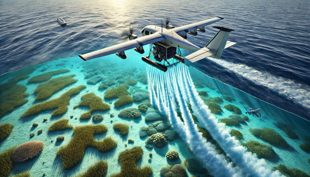
The innovation of the Batimetric Lidar in the EIA project
Traditionally, monitoring of marine environments was based on acoustic techniques such as echocandal and manual optical methods, including the bucketUsed to measure the transparency of water. However, these technologies have significant limits: Sonar require the use of boats and long -term detection times, while the bucket disc only offers a qualitative estimate of the clarity of the waters and does not allow precise information about the morphology of the seabed.
With the EIA project (Marine Ecosystem Restoration), Airborne Lidar Bathymetry (Alb) is introduced, an innovative technology with which you can collect high -resolution data through laser impulses. This system makes it possible to obtain a detailed mapping of the seabed with higher efficiency than traditional methods. In fact, it includes enormous areas in reduced times and it reduces the environmental impact of the detection activities.
The system used in the EIA project is the Rapid Airborne Multibeam Mapping System (Ramms) 2.0, developed by the Dutch company FugroLeader in the sector of geological, geophysical and environmental reliefs. Thanks to the double laser configuration and an acquisition frequency of 60 H, we let us try to understand better.
Comparison between buckets and Batimetric Lidar
Il bucketIntroduced in 1865 by the Italian astronomer and oceanographer Pietro Angelo Secchi, is a traditional method for measuring the transparency of water. The tool consists of a white disk or white and black sectors, which is immersed to the point where it is no longer visible. The depth that it disappears gives an empirical indication of the amount of particles that are suspended in the water column.
Although the dry disk is still used to obtain rapid and economic estimates on the clarity of the waters, the Batimetric Lidar offers a considerably higher level of precision. Although the first is based on human observation and is influenced by the lighting conditions and subjectivity of the operator, the Lidar uses laser impulses to cross the marine surface and collect quantitative data about the transparency of the water, about the morphology of the seabed and About the distribution of the ranks of Posidonia.
The most important advantage of this technology is the possibility to collect detailed information in large areas and in a short time, without the need for operations at sea. That continuous and more reliable monitoring then guarantees traditional methods. But why is it so important to check the Phestogams?
Marien Fans’s role in retaining ecosystems
The improvement of detection techniques is of fundamental importance for the protection of marine fans, including Poseidonia Oceanica. The ranks of Posidonia in fact represent one of the most vital and productive ecosystems of the Mediterranean: they offer refuge, nutrition and reproduction areas for numerous marine species. These habitats play an essential role in the stabilization of sediments, contribute to the coastal balance and prevent the erosion of the beaches. Thanks to their ability to absorb and store large amounts of carbon dioxide, they are also fundamentally in the limitation of climate change.
Despite their ecological importance, these meadows undergo growing threats with regard to human activities. The pollution caused by industrial and agricultural discharges endangers the quality of waters and promotes the spread of invasive algae that hinder the photosynthesis of Posidonia. Travel fishing destroys huge parts of the prairie, while the non -regulated anchoring of the boats tears and destroys the radical structures of these plants, making their regeneration difficult. Global warming also influences their survival, changing the temperature of the water and changing ecological balances, with the risk of promoting the spread of exotic species that are harmful to the ecosystem.
In this context, the Batimetric Lidar enables you to check the distribution and health of the Posidonia in detail and to identify all areas subject to regression. This information is essential to take targeted conservation measures, such as setting up integral protection areas and the recovery of compromised habitats.
Challenges and opportunities for environmental monitoring
Although the Batimetric Lidar represents significant technological progress, its effectiveness is influenced by environmental variables, including water turbidity. The presence of suspended sediments, especially high in the winter months because of the rains and river contributions, can reduce the laser signal and reduce the quality of the surveys.
To overcome this restriction, the EIA project uses an integrated approach, in which Lidar data is combined with acoustic reliefs and multispectral images. With this methodology you can compensate for the difficulties related to turbidity and get a more detailed picture of the dynamics of marine ecosystems, which facilitates the planning of more effective conservation strategies.
A further critical factor is represented by climate change, which considerably change the ecological balance. The increase in temperatures promotes the proliferation of invasive exotic species, such as the Caulpa Cilindracea seaweed, able to choke the indigenous fanserogame. In addition, the acidification of the oceans and increasing sea level are in danger in danger the regeneration capacity of the marine prairies. Thanks to Lidar, these transformations can be observed in real time and develop more effective adjustment strategies.