
URBANIZATION, CLIMATE CHANGE AND POLLUTION ARE TESTING THE PLANET’S GREEN HERITAGE. TO RESPOND TO THESE CHALLENGES, THE CARABINIERI HAS LAUNCHED THE SMART FOREST MONITORING PROJECT, AN INITIATIVE THAT COMBINES TECHNOLOGICAL INNOVATION AND INTERNATIONAL COLLABORATION. THE RESULTS ACHIEVED HAVE BEEN PRESENTED AND THE NEXT STAGES OF THIS IMPORTANT PROGRAM HAVE BEEN DEFINED
The project “Smart Forest Monotoring”. A journey between innovation and tradition
Born in 2023 with an inaugural workshop in Boston (USA) titled “Smart Forest in Smart Cities”the project saw the participation of a delegation led by the General Andrea Rispoliof the Forestry, Environmental and Agri-food Unit Command of the Carabinieri (CUFAA). On that occasion, an important agreement was signed with the Massachusetts Institute of Technology (MIT), which laid the foundations for an international scientific and technological partnership.
After stopping at Maker Faire Rome in October 2024, where the device was unveiled Greenery Scannercapable of analyzing the state of health of urban greenery, the project is preparing to reach new goals after the conference on 9 December 2024 at Palazzo Valentini, in Rome. This event was not only a moment of discussion but also an opportunity to illustrate the results achieved so far and outline the next stages of an initiative that aims to become a reference model in the sustainable management of natural resources. But let’s see what it’s about.
Technologies at the service of the environment
At the heart of this initiative are innovative technological tools which, by integrating environmental data and artificial intelligence, offer an unprecedented understanding of forest ecosystems and their evolution.
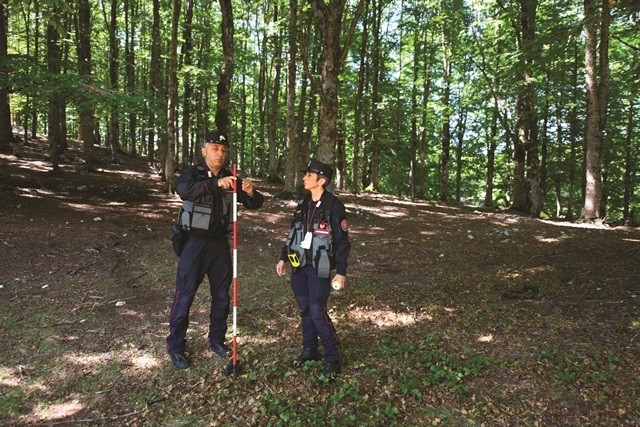
One of the flagship tools is the Tree Talkera sensor network developed in collaboration with the WITH. This system, installed directly on the trees, collects a series of fundamental data, such as carbon dioxide absorption, hydration levels and environmental stress indicators.
Thanks to this technology, it is possible monitor tree health in real timeensuring timely and targeted interventions both in urban contexts, where trees help mitigate pollution and the microclimate, and in natural forests, which represent bastions of biodiversity. But there’s more.
LichenEye: innovation at the service of nature
The system LichenEyedeveloped within the project “Smart Forest Monitoring”uses Artificial Intelligence to analyze the diversity and distribution of lichen epiphytes. These, which grow on living surfaces such as trunks and branches, offer a privileged observation point on the health of forest and urban ecosystems.
The result of the symbiosis between a fungus and an algae or a cyanobacterium, epiphytic lichens live in environments with a delicate chemical balance and are very sensitive to atmospheric pollutants, such as nitrogen oxides, sulfur dioxide and particulate matter. This peculiarity makes them natural bioindicators highly effective: their presence, growth and diversity are closely linked to the degree of purity of the environment in which they are found.
In urban environments, where air pollution represents one of the most critical challenges, the analysis of lichens allows us to identify particularly vulnerable areas.
Thanks to machine learning and remote sensing technologies, LichenEye not only catalogs the presence of lichens but interprets the data to signal any changes in the environmental balance.
Il remote sensing
Among the key technologies used by the project, the remote sensinga remote sensing methodology that uses very high resolution satellite imagery to map forests on a national scale.
This tool allows you to identify the characteristic parameters of multiple forests “old”real “treasure chests of biodiversity” for the unique variety of flora and fauna they host. Through remote sensing, it is possible to plan strategic interventions to preserve these precious ecosystems, thus preventing degradation and promoting resilience in the face of climate change.
Monitoring urban greenery: technology and sustainability for cities
Among the central aspects of the project “Smart Forest Monitoring”monitoring urban greenery represents a fundamental pillar for addressing the challenges of urbanization and climate change.
Cities, increasingly vulnerable to the effects of air pollution and rising temperatures, find in urban forests an indispensable ally to improve the quality of life of citizens and guarantee the sustainability of metropolitan contexts.
One of the most significant initiatives in this area is the project “Greenspaces”developed by Municipality of Rome in collaboration with the Forestry, Environmental and Agri-food Unit Command of the Carabinieri (CUFAA). This program takes advantage of Digital Twinsdigital models that virtually replicate the state of urban greenery, allowing innovative and strategic planning of the management of green spaces.
Thanks to this advanced technology, it is possible to simulate the effects of targeted interventions and optimize resources for the care and protection of trees and green areas.
The role of forests
The urban forestshowever, are not simply decorative elements. They play a fundamental role in regulating the city’s microclimate. In fact, they contribute to absorbing fine dust and mitigating the effect of heat islands, a phenomenon that makes cities significantly warmer than the surrounding areas.
Furthermore, thanks to their ability to capture carbon dioxide and release oxygen, they help improve air quality, reducing the negative impact of pollution on public health.
In addition to the environmental benefits, urban forests offer vital spaces for the sociality and psychophysical well-being of citizens. Parks and gardens become places of aggregation, they also encourage physical activity and contact with nature in a context increasingly dominated by concrete and the frenzy of modern life.
In this context, the monitoring of urban greenery, integrated with technologies such as the Greenery Scanner and other digital solutions, is not limited to safeguarding trees but contributes to create more resilient and livable cities.
But let’s get to the partners “excellent”.
A network of excellent collaborations
One of the most significant partnerships of the project is that between CUFAA and the National Research Council (CNR). This cooperation has led to the development of innovative projects, such as the study of forest infestations through remote sensing, a technique that uses satellite data to monitor and prevent damage to forest resources.
At the same time, the contribution of Council for Agricultural Research and Analysis of Agricultural Economics (CREA) was fundamental for updating the National Forest Inventory, a crucial tool for mapping and managing the Italian forest heritage. This inventory provides detailed data on forest characteristics, enabling sustainable planning and efficient control of natural resources.
No less relevant is the synergy with theEuropean Space Agency (ESA), which allowed the integration of latest generation satellite technologies into the project. Thanks to the constellation IRISa network of high-resolution satellites, have been developed Service Value Chainsadvanced monitoring chains capable of identifying critical phenomena such as forest fires, illegal deforestation or environmental degradation.
These systems, based on aaccurate analysis of satellite datarepresent a revolution in prevention and intervention capacity, offering rapid and effective responses to environmental emergencies.
But what makes it unique “Smart Forest Monitoring” it is the ability to transform scientific research into concrete and tangible actions. The tools developed within the project do not just monitor the environment, but provide practical solutions to protect it. The alliance between technology, science and institutions has made it possible to create an integrated network, in which innovation translates into real benefits for the environment and the communities that depend on it.